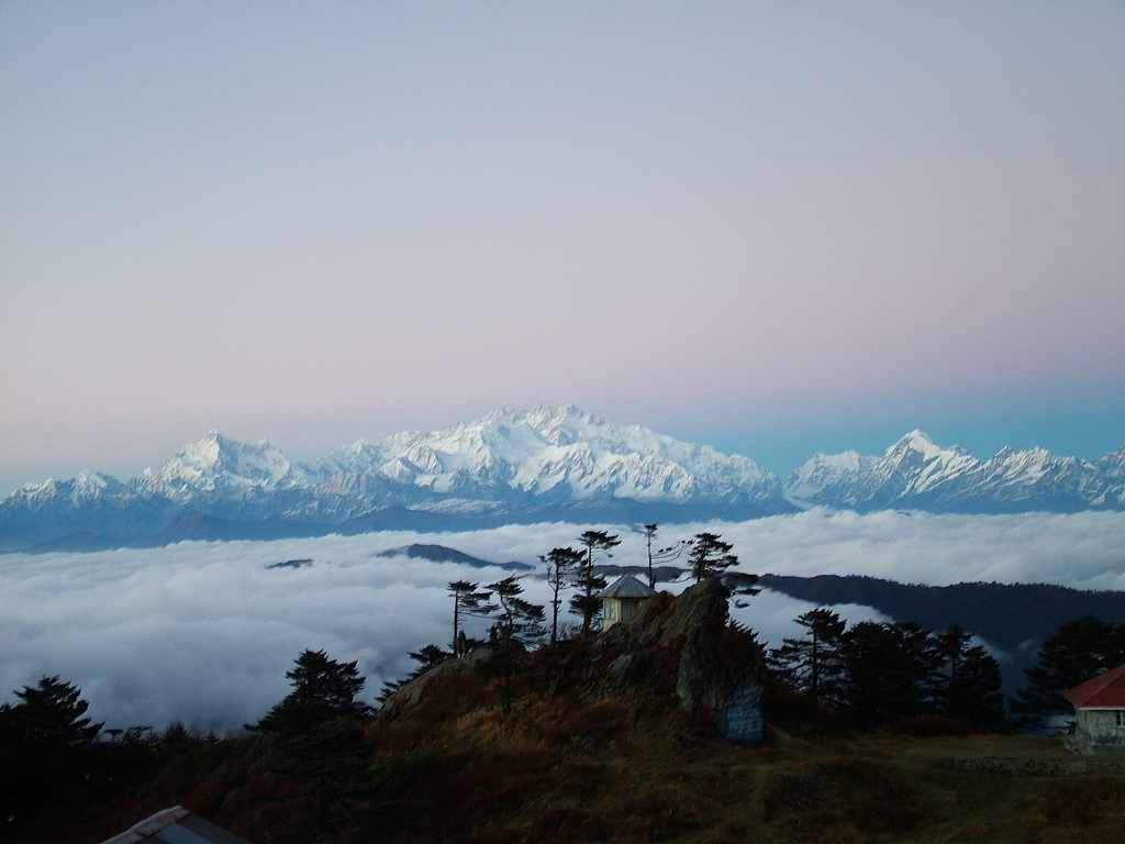
 Sandakfu
 or
Sandakphu (3636 m; 11929 ft) is the highest peak in the state of
West Bengal,
India. It is situated at the edge of the
Singalila National Park in
Darjeeling district on the
West Bengal-
Sikkim border, and is the highest point of the
Singalila Ridge. Sandakphu has a small village on the peak with a number of hostels. The peaks of
Kanchendzonga and
Everest can be seen from its summit.
From Sandakphu the best view of the mountain Kanchendzonga is
possible, which is known as the sleeping Buddha or the sleeping Shiva.
============================================================

How to reach
Sandakphu can be reached by trekking. The trekking starts from
Maneybhanjang via Chitirey, Meghma, Tonglu, Tumling, Gairibas,
KalaPokhri, Bekhey to Sandakphu.
============================================================
Trekking

The trek along the Singalila Ridge to Sandakphu and
Phalut
is one of the most popular ones in the Eastern Himalayas due to the
grand vistas of the Kanchenjunga range and the Everest range which can
be seen from the ridge, and also for the seasonal wildflower blooms and
birding. Treks begin at Manebhanjan which is 51 km (1.5 hours by road)
from Darjeeling.
The trekking routes inside the Singalila National Park have four legs or stages.
- Manebhanjan to Meghma (2600 m): This is a 4 hour trek through the lower forest.
- Meghma to Gairibans (2621 m): There are two alternative trekking
routes. Both go via Tonglu (3070 m) and Tumling (2900 m). The boundary
of the national park passes though Tumling where a checkpost is located.
From Tumling, a shorter trail cuts through Nepal and Jaubari (2750 m).
- Gairibans to Sandakphu (3636 m): This is a steep 4 hour climb. Roughly halfway up the climb is the village of Kala Pokhri (3186 m).
- Sandakphu to Phalut (3600 m): This is the most pristine stretch of
the trek, offering great views of Kanchenjunga and Mt. Everest. It is a
one-day trek via Sabarkum (3536 m) covering 21 km. But the main problem
of this Sandakphu-Phalut route is that there is no water source in
between, so the trekkers have to carry enough water to reach Phalut.
The descent from Sandakphu can be accomplished in several ways:
- Retracing the way back to Manebhanjan.
- A steep descent to the village of Sirikhola on the banks of the River Sirikhola, via Gurdum (2300 m), and from there to Rimbick.
- There is now a 4WD motorable road to Sandakphu, so one can hire a
cab down to Manebhanjan and Darjeeling via Tumling and Tonglu if needed.
The drive on the gravel road, however, is very arduous.
================================================================
Climate
The temperature swings from -20°C (including wind chill factor) in
winter to +15°C in summer. Sandakphu gets snowfall in late December to
early February.
 Sandakfu or Sandakphu (3636 m; 11929 ft) is the highest peak in the state of West Bengal, India. It is situated at the edge of the Singalila National Park in Darjeeling district on the West Bengal-Sikkim border, and is the highest point of the Singalila Ridge. Sandakphu has a small village on the peak with a number of hostels. The peaks of Kanchendzonga and Everest can be seen from its summit.
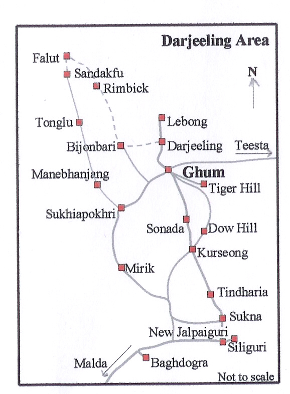
 The trek along the Singalila Ridge to Sandakphu and Phalut
is one of the most popular ones in the Eastern Himalayas due to the
grand vistas of the Kanchenjunga range and the Everest range which can
be seen from the ridge, and also for the seasonal wildflower blooms and
birding. Treks begin at Manebhanjan which is 51 km (1.5 hours by road)
from Darjeeling.
The trek along the Singalila Ridge to Sandakphu and Phalut
is one of the most popular ones in the Eastern Himalayas due to the
grand vistas of the Kanchenjunga range and the Everest range which can
be seen from the ridge, and also for the seasonal wildflower blooms and
birding. Treks begin at Manebhanjan which is 51 km (1.5 hours by road)
from Darjeeling.


